
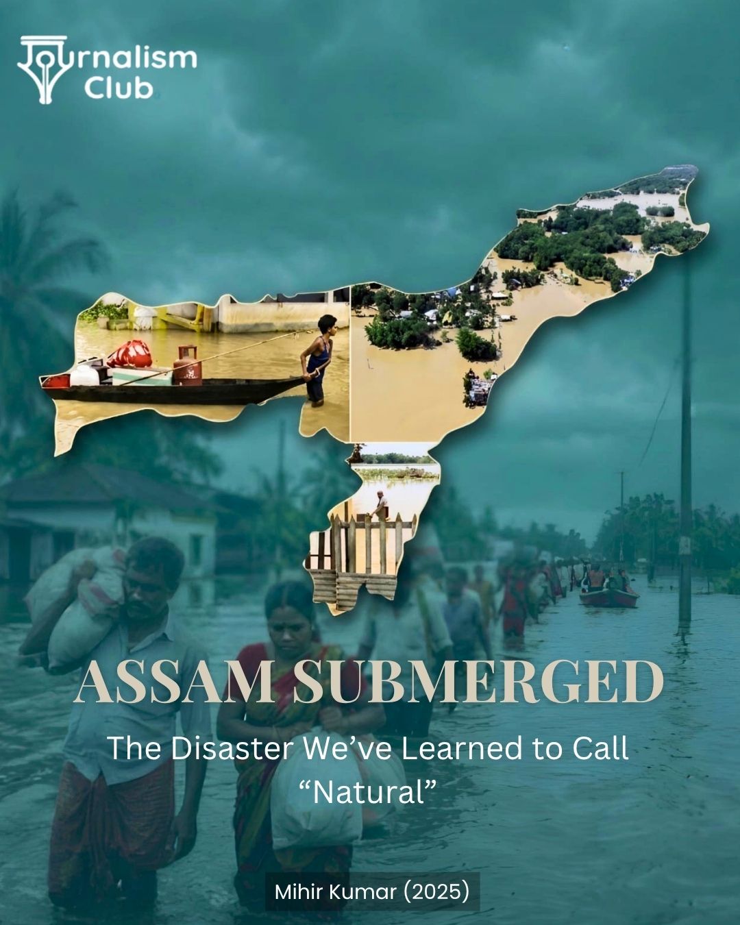
ASSAM SUBMERGED: THE DISASTER WE HAVE LEARNED TO CALL “NATURAL”
Assam has never been a stranger to floods. Every year, with the advent of the monsoon season, the Brahmaputra and its tributaries swell and overflow their banks. For a state that is drained by one of the world’s great rivers, floods are an integral part of the ecosystem. The Brahmaputra provides an immense flow of water and silt from the Himalayas down the river valley to the plains, and hundreds of tributaries carry off excess water from the hills, enriching the wetlands and creating a delicate habitat for sustaining life. Thus, it is the very geography that determines the flood pattern and distribution. In this particular ecosystem, floodwater is a necessity for fertility and survival. But beyond a certain point, when the floodwater submerges human settlements, the consequences turn destructive and devastating to human life and property
This year, however, Assam is confronting a different dilemma. Beyond the perennial problem of widespread flooding, 2026 has brought uncertainty over its geographical spread. Areas once considered relatively safe have also been inundated, blurring the line between Assam’s traditionally flood-prone regions and those that were thought to be comparatively secure. The result is a troubling shift: flood risk is no longer confined to the places that have historically borne the brunt of the disaster.
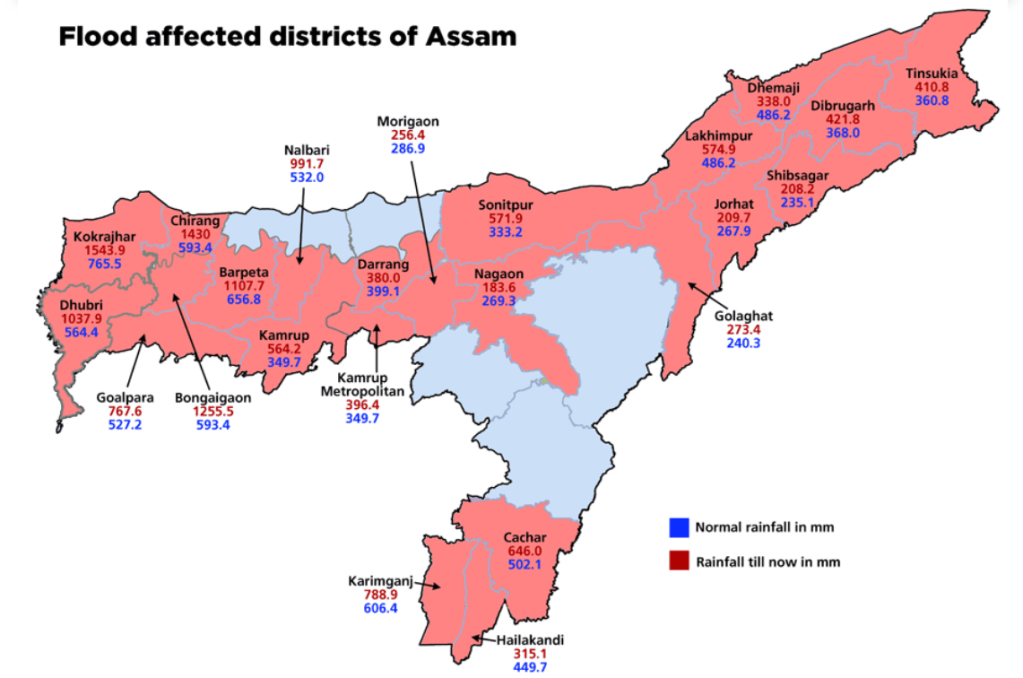
As of August 10, 2026, the official statistics registered approximately 100 dead and 1.37 lakh people affected by the floods. It is indeed surprising that Assam has witnessed frightening floods this year despite relatively low levels of rainfall during the flood season. But where exactly did this water come from, and why is it attacking with such force, swallowing everything in its path, and why are there places that can no longer resist its advances?
THE LANDSCAPE, THE RIVER, AND THE CLIMATE
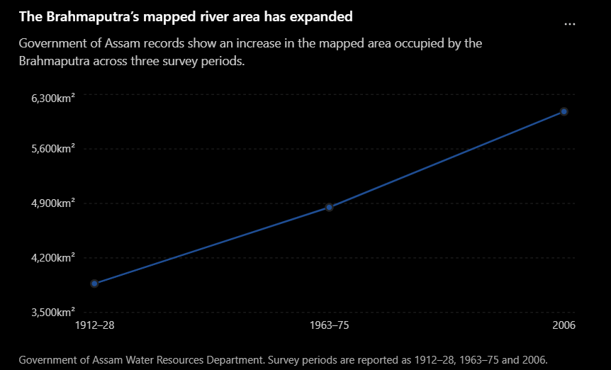
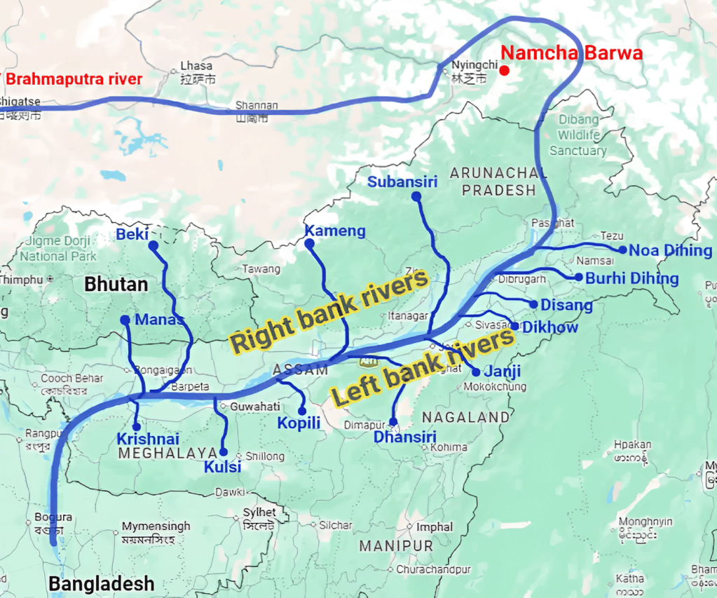
The first reason to consider is the geography of Assam. The region is located at the confluence of the Eastern Himalayas, the Patkai-Naga ranges, and the Meghalaya highlands, while the Brahmaputra valley serves as a huge channel through which torrential waters from a large catchment area downstream converge. Rivers coming down from high altitudes have a steep slope, and after flowing into the valley, they lose their velocity and consequently form floodplains. Thus, Assam is naturally subjected to periodic large-scale inundation. To put it another way, the Brahmaputra is a huge and powerful river that constantly shifts its sands and channels, creating new distributaries and abandoning old ones, with an enormous amount of silt and debris in its flow. The river’s numerous chars (sandbars) often form and reform during the monsoon season, and the confluence of large tributaries such as Dhansiri, Doyang, Dikhow, Disang, and Bhogdoi with it during the rainy season causes significant overflows of the banks. Thus, there is a natural basis for the annual Assam deluge. However, this does not automatically mean that all human activities are useless and ineffective in the face of nature’s power.
Another factor to consider is the relationship between the flood and the local ecosystem. Inundation in the Assam region could be beneficial for the wetlands and the natural floodplain ecosystem that presumably existed before the development of urban centers and large-scale agriculture. Accordingly, human impact may turn out to be a critical factor in catastrophic flooding if the settlements are built on potential floodways or if any ecological damage was done to them due to human activity. However, climate change also plays a role in the situation. Thus, the phrase “caused by climate change” is significantly too simplistic to attribute the 2026 flood to climate change alone. Individual climate factors, acting independently and together, affect the formation and development of floods. In particular, for a given year, the amount of rainfall, the size of the river basin, and the amount of erosion in the basin must be studied to determine the specific cause-and-effect relationships. The phrase “caused by climate change” ignores other contributing factors, but neglecting climate change would also be misleading. A warmer climate allows the air to hold more moisture, and shifting weather patterns can lead to more extreme short-term rainfall, among other mechanisms.
Thus, the most accurate assessment would be to say that climate change acted as an aggravating factor for the annual Assam deluge, but it is not the sole cause of it. Heavy rains during the monsoon season can lead to significant flooding of the Brahmaputra if there are areas of wetlands that can store the excess. Such wetlands are small in number because natural wetlands have been replaced by paddy fields, or their function has been inhibited due to human activity. High flows of the Brahmaputra in the river valley create additional problems owing to the destruction of infrastructure and natural barriers such as levees. Finally, extreme rainfall is more difficult to predict and adapt to in the context of climate change, because there is a decreasing amount of land for water to infiltrate into.
SEVEN DECADES OF FLOODS
Assam’s present water disaster takes on greater dimension when viewed through the long period of severe deluges in 1954, 1972, 1977, 1988, 1998, and 2004. Each of these had an impact on policy design for managing floods in Assam. The 1950 earthquake that triggered floods led to the building of structures like embankments, which checked the fury of the rivers, protecting crops and settlements.
However, 1988 witnessed the breach of embankments, resulting in widespread flooding. The policy position has been to protect life and property by embankments, which have reduced the frequency of floods but prevented neither the deluge nor loss of lives.
As the years rolled by, policymakers realized that embankments could not provide foolproof protection. Gradually, the flood management policy began to move away from the paradigm of “protective development” to management, and planning and policy emphasis shifted to disaster response, mitigation, and preparedness. However, even now, policymakers do not understand that embankments reduce the impact of floods but cannot eliminate flood risk in Assam.
The Assam experience teaches us to manage flood risks through a combination of embankment and floodplain planning, while embankments will continue to play a role in flood management, they must be supplemented by other measures such as conservation, drainage, floodplain management, and early warning and preparedness.
TRACING THE WATER UPSTREAM
The problem with floods is that it is considered an administrative issue but rivers do not recognize political boundaries. Consider the Dhansiri and Doyang rivers, both of which rise in Nagaland and flow into Assam. The physiography, and therefore the hydrology, of these rivers is determined by rainfall and land use in Nagaland, which is outside the administrative control of Assam. Torrential rains on steep slopes result in large volumes of water rushing down rapidly into the comparatively flat terrain of Upper Assam Valley. In the lower reaches of the river, the current slows down and spreads out laterally, presenting additional challenges if the downstream river is already swollen and flowing at a higher speed. If the downstream channel is shallow and silty, the flood current has even less room to expend its energy, and the floodplain is entirely inundated, presenting multiple hazards to life and property. Thus, a locality in Assam can be ravaged by floodwaters originating hundreds of kilometers away, and in the case of the Dhansiri or the Doyang, even in another state.
This highlights the need for greater cooperation between states in flood management, including the sharing of real-time data on rainfall, upstream water levels, and the modeling of likely impacts in downstream areas. This would allow downstream districts to prepare for the impending deluge based on objective scientific analysis. The basic issue is that the river basin extends beyond the administrative jurisdiction of any one agency. The same consideration applies to the Brahmaputra, which flows through China as the Yarlung Tsangpo, turns south and west through the Himalayas to form the Siang or Dihang in Arunachal Pradesh, and finally flows into Bangladesh as the Brahmaputra proper.
While India’s concerns about China’s proposed dams on the Tsangpo are certainly justified, there is no reason to believe that Assam’s perennial flooding problem can be solved by erecting barriers on the river’s very reaches that lie within Chinese territory. The proximate causes of the Assam floods are always going to be rainfall, run-off, and the state’s inadequate capacity to deal with large volumes of water. The long-term implications of altered hydrology require greater attention. If the upstream flow in the Yarlung Tsangpo is regulated, it will have downstream consequences for the Brahmaputra. Given that both nations have technical expertise in hydrology, they must develop a framework for sharing such data. The expert-level mechanism that already exists between India and China could facilitate this type of discussion.
Furthermore, flood management in Assam, which involves upstream states like Nagaland, is a matter for greater regional cooperation, including Bangladesh, Bhutan, China, and the other riparian states within India. After all, rainfall in Assam does not differentiate between Bangladesh and Arunachal Pradesh, and the response to it cannot be managed within administrative boundaries either.
THE MAP OF VULNERABILITY IS MOVING
While basin-level analysis helps understand the larger trends, the division of Assam into districts sees different geographical challenges and vulnerabilities. Golaghat, Sivasagar, and Jorhat are typical examples of the variations possible within one state.
The vulnerability of Golaghat is largely determined by the catchment areas in the Dhansiri and other rivers, while Sivasagar has issues with the overflow, drainage, and lower lying areas. In Jorhat, the river systems combine with the impact of urban sprawl, transportation infrastructure, and drainage. It is evident that Assam as a whole cannot be considered as one flood-prone region. District-level variations mean that the vulnerability of any region depends on the complex interaction of many factors. A particular wetland may have been able to hold excess water before but could have been built over. A canal might have been dug, narrowing the width of the river. Drainage can be impeded by a railway line or embankment. Or a village, once on the periphery of a city, can now find itself in the middle of an expanding conurbation.
It is at this intersection that human activity can contribute to the problem.
For instance, Assam has numerous embankments built for flood control. Although they can offer excellent protection, their effectiveness must be considered in the context of the larger environment. If the river levels rise beyond the embankments, water will pour into the protected areas unimpeded. Once the levels recede, the embankments can also hinder natural drainage. Another factor in Assam’s problems could be the degradation of natural wetlands. These have been critical in storing and redistributing water in the region but have been lost due to urban expansion and other forms of encroachment. Roads and railways can also act as impediments to drainage when built without necessary cross drains, creating man-made embankments.
Simultaneously, sediment is a crucial aspect of the flood situation. The Brahmaputra carries enormous quantities of sediment, some of which are deposited during floods, changing the riverbed and consequent drainage patterns. While some of this is natural, there could be human factors that impact sedimentation processes. In Assam, erosion can lead to massive changes in a river bank, with the land sliding into the water or creating new streams. With each factor impacting the river, the flood situation in Assam becomes a complex phenomenon, and no aspect of it can be isolated as the sole reason for the disaster.
THE HUMAN AND ECOLOGICAL COST
The costs of a disaster like Assam’s floods go far beyond just water entering a home.
For farmers, long periods of waterlogging can destroy their crops and livelihoods. Sand from the flood can render large regions of farmland infertile. Agricultural and tea workers may see their incomes and wages affected due to disruptions to the supply chain. People may need to be shifted to relief camps or shelters, while healthcare, education, transport, and business infrastructure may need to be rebuilt. Essentially, floods lead to long-drawn disruptions to the social and economic fabric of the flood-affected region.
Disasters like these rarely impact everyone equally. People have different levels of access to better housing, infrastructure, and resources. As a result, while many may be struggling to survive or even relocate, those with more resources can have their lives disrupted but not upended. Displacement can be both permanent and temporary, and for many, it means leaving behind their homes, jobs, and way of life. While some people can return to their homes, rebuild their structures, and resume their old lives, those who had little to begin with may have to contend with the harsh realities of a new ecosystem. Thus, Assam’s vulnerability is both natural and socio-economic.
Ecologically, the flood plains of Assam are diverse and complex. While the impact of flooding is devastating for human life, it must be considered in the larger context of the region. Floods can provide fresh water and nutrients to wetlands, which in turn can support the entire ecosystem. Natural floods are part of the life cycle of the region, and for species such as the one-horned rhinoceros in Kaziranga, they are an essential part of their survival. However, the same floods, when they occur beyond normal levels, force the animals into higher grounds with little or no respite, putting them in close proximity with human settlements and infrastructure. It is another illustration of the precarious balance that the people and wildlife of Assam have to navigate.
ARE WE SOLVING THE WRONG PROBLEM?
Floods in Assam have been dealt with using the same strategy for decades. The focus has been on controlling the waters and protecting property, and the state has devoted a large amount of its resources to embankments, spurs, and other related infrastructure. In addition, disaster management in Assam has seen an improvement in recent years. Authorities now have more effective warning systems to alert people in flood-affected areas, evacuation plans are better organized, and the state provides relief to those displaced by the disaster. There are even smartphone apps that allow digital mapping of the damage and quicker compensation in certain cases.
However, what we need now is a paradigm shift. A state that is efficient at responding to a crisis can fail to prevent it in the first place. Better response mechanisms do not necessarily reduce the damage in the long run, especially when the cause of the damage continues unabated. If Assam is being flooded year after year, the response measures after the fact only manage the symptoms. The authorities need to focus on the underlying issues that cause people to live in vulnerable locations and situations.
The government must consider the damage not in terms of lives lost or properties destroyed but as an opportunity to reduce exposure. Authorities should strive not only to protect the flood plains but also to encourage development in alternate ways. The response to Assam’s floods must be comprehensive, spanning multiple sectors and involving the people on the ground in actual decision-making. The government must understand the vulnerability and build resilience instead of simply responding to the disaster.
Engineering remains an important aspect of this solution. It will always be a part of flood management in Assam, but it must be balanced with other aspects, including ecology, administration, and preparedness measures. The state must build upon existing infrastructure by focusing on its ability to withstand floods. Flood management authorities must work with other government departments and agencies to develop long-term sustainable solutions that factor in the rising impact of climate change and ensure the safety of the people and the environment in which they live.
BUILDING A FLOOD-RESILIENT ASSAM
Instead of trying to fight the floods, the government of Assam needs to learn to live with the Brahmaputra’s annual deluge.
The first step towards this would be to create dynamic floodplain zonation maps that take into account recurring flood patterns, the river’s active floodplains, and wetlands which can be used to store excess water during the rainy season. These maps need to be regularly updated since the Brahmaputra is known to change its course over time and the flood patterns are likely to change as well with climate change.
The next step would be to restore natural floodplains, wetlands, and beels wherever possible. These need to be prioritized in the overall development plans of the state. The flood management strategies need to include infrastructure that is flood resilient and can withstand the rising waters for as long as possible. Roads, railway lines, and other structures have to be built with sufficient drainage so that they do not create alternate embankments. Schools and hospitals in vulnerable areas need to be evacuated, relocated, or fortified to ensure they remain functional in the wake of a disaster. Other public and private infrastructure also needs to be upgraded accordingly. Farmers need to be encouraged to cultivate flood-resistant crops and build alternate sources of income. The agricultural economy needs to diversify to reduce dependence on paddy cultivation which is highly affected by floods and has a long gestation period. Flood prediction and early warning has to be made more localised so that the people in the affected areas can be notified well in advance.
It is also important to note that flood management is a collective responsibility. The authorities in Assam need better coordination at the local level when responding to a disaster. It is equally important to develop long-term strategies to prevent such a disaster. The state has to work in tandem with other states that share the Brahmaputra basin, and coordinate with national agencies like the Water Resource Ministry and the India Meteorological Department. The entire ecosystem, both human and natural, has to be nurtured so that the flood impact is reduced and the vulnerable population can withstand it.
CONCLUSION
Floods will continue to be a part of Assam’s ecosystem as long as the region remains dependent on the Brahmaputra. Monsoon rains, Himalayan geology, and the massive sediment load of the river are unlikely to change in the foreseeable future.
What may change is the human intervention in this natural process. After decades of encroachment, it is natural for the river to reclaim its own in Assam. However, it is also a matter of perspective. The river is merely doing what it has always done, but the vulnerability of the region has increased dramatically. This is a direct consequence of human activity because people have made poor decisions in building their habitats. A house built on a natural drainage canal is a man-made vulnerability. So is an embankment built poorly or not maintained at all. A warning system that does not function or a disaster response system that is unprepared is also a man-made problem. Each of these failures contributes to the destructive nature of Assam’s floods. Therefore, the very phrase ‘natural disaster’ is misleading and disingenuous. It is easy to blame nature and forget the role played by humans.
The real lesson from Assam’s floods lies in the shifting landscape of vulnerability. If the region’s flood management is inadequate, it is because ‘safe’ areas have increasingly been turned into vulnerable pockets. The next time Assam has its annual deluge, it needs to understand that it does not merely have a ‘natural disaster’ but a ‘man-made disaster.’


Leave a comment